Search the Community
Showing results for tags 'Navigation'.
-
 To work in Singapore, it need 2 additional features: Which route can siam ERP Where has free parking BTW, I do support this initiative by Google, and this is one of the way to go green. Source #1: https://www.theverge.com/2022/9/7/23339954/google-maps-eco-friendly-routing-expanding-europe-fuel-types Source #2: https://blog.google/around-the-globe/google-europe/eco-friendly-routing-in-europe/ Google is expanding Maps’ eco-friendly routing mode, rolling the feature out in dozens of European countries and making it even more powerful by letting you pick what type of fuel your car runs on. The feature, originally launched in the US and Canada last year, will highlight routes that use less energy if they have a similar ETA to other alternate routes. Google says that starting today, it is rolling out to users in “nearly 40” European countries, including France, Ireland, Poland, Spain, and the UK. (It was introduced in Germany last month.) Google’s also adding the ability to tell Maps if your car has a diesel, gas, hybrid, or electric powertrain, so it can find the most efficient route for your specific type of vehicle and provide more accurate estimates on how much more efficient the eco-friendly route is. The system is built on information pulled from the US Department of Energy’s National Renewable Energy Laboratory (NREL) and European Environment Agency, combined with Google Maps driving trends to train machine learning models based on the most popular engines in given regions. Using an example from Google’s blog post, this could mean that people with diesel-powered vehicles will be routed along a high-speed freeway, where their engines will be most efficient, whereas someone with a hybrid or electric vehicle might get suggestions including surface streets where they can take better advantage of regenerative braking. Helping you make sustainable choices with Google Maps and beyond Whether you’re staying local or traveling, Google can help you get where you need to go more sustainably with a few helpful tips: It’s electric! If you have an electric vehicle, just search for “EV charging station” on Google Maps to see charging stations nearby, along with helpful details, like port types and charging speeds. And for some stations, you can even see if a charger is available right now, helping you avoid the wait and save valuable time. Swap four wheels for two. Often, the most sustainable choice doesn't involve a car at all, and Google Maps can help you with alternate ways to get around. We recently announced more cycling route information, including a more detailed breakdown of your route and whether you’ll encounter heavy car traffic, stairs or steep hills on the way. And you can find nearby bike and scooter shares in over 500 cities around the world including Barcelona, Berlin, London, Paris, and Rome. Walking the walk. Google Maps offers turn-by-turn directions for pedestrians. To ensure you’re not walking the wrong way, Live View uses augmented reality to display arrows and directions clearly overlaid on the map. Plus, you can preview your walking route with Street View. Navigate public transport with ease. By tapping on the transit icon in Directions, you get directions to your destination by bus, train, subway and even ferry. When available, you can see real time arrival and departure times, transfers, and service delays. And Google Maps gives you all the information you need to be prepared, like how crowded your ride will be, what the temperature is like, and if there are wheelchair-accessible routes available. Sleep more sustainably. Google Search helps you find hotels that have made significant commitments to green practices. Hotels that are certified for meeting high standards of sustainability from certain independent organizations, like Green Key or EarthCheck, will have an eco-certified badge next to their name. This helps you understand their eco-friendly practices, from waste reduction to energy efficiency to water conservation measures.
 -
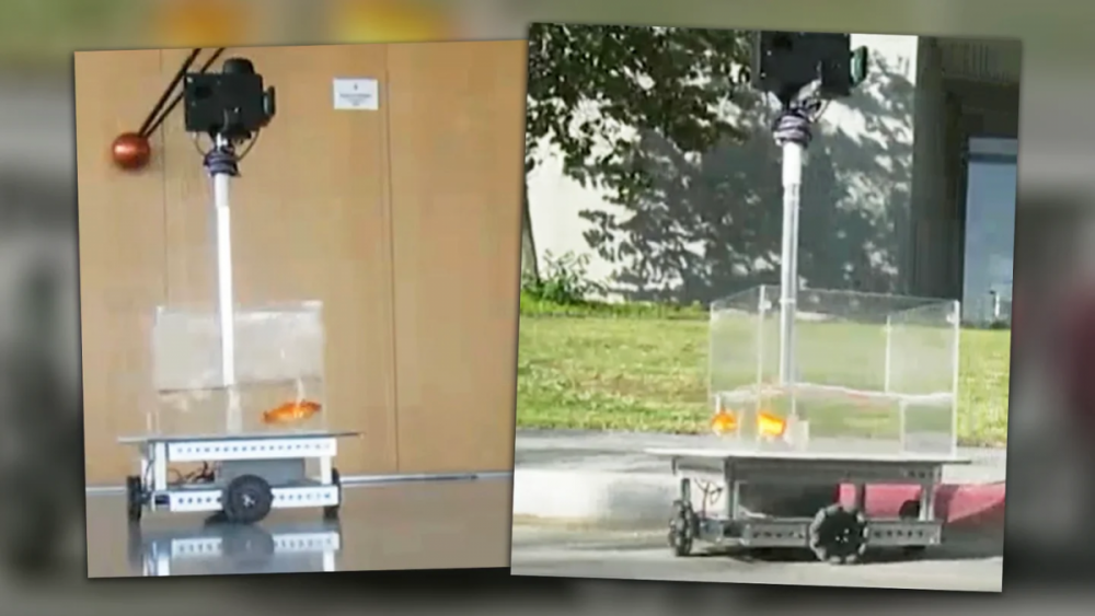
<Scientists Trained Goldfish to Drive a Little Car It's proof that fish are capable of navigation even in unfamiliar environments. Scientists often create elaborate studies in order to tease out secrets and truths from the animal world. One such work has recently been published, with a group from Ben-Gurion University hoping to determine the true nature of a fish's navigation capabilities, as shared on Twitter. Several goldfish were tasked with driving a robot towards a goal, with the sea creatures proving more than up to the job. As per the paper available online, the apparatus for the test was relatively straightforward. Goldfish were placed in a small transparent tank of water placed on top of a robot chassis. A camera mounted above the tank tracked the fish's position and orientation. If the fish swam outward towards a given wall, the robot would move in that direction. When the fish drove up to a pink target on the wall, they would be rewarded with food. Initially, the six fish in the study drove around largely at random. However, tests were regularly performed three times a week, and the fish quickly began to learn that if they drove over to the target area, they would receive food. Over time, the fish became more capable, and could trigger the reward mechanism more times in a single given 30 minute test session. The researchers wanted to further determine just how well the fish had learned to understand their terrestrial environment. The starting position in the room was changed, and the fish were still able to navigate to the target for a reward. Similarly, adding decoy targets of different colors in the room did not stop fish from achieving the task. As a further test, the pink target was moved to a different location in the room and the fish were tested again. Initially, fish drove towards the old target location in an attempt to receive a reward. When none was forthcoming, the fish eventually learned that the pink target itself was the key to the task, and began to drive there instead. The study suggests that a goldfish's navigational abilities are not solely limited to the underwater environment to which they are accustomed. Indeed, a fish can learn to drive a robot in order to secure food. Furthermore, the tiny creatures are also able to build a greater understanding of their world, proven by learning that reaching the pink target, and not simply the original target location, is key to receiving a reward. It also helps clear up the widely-disproven myth that the common pet fish only have a 3-second memory. We've seen similar studies before, which may seem frivolous, but they teach us a great deal about how organic brains work and their true capabilities. We're still likely a ways off from teaching dogs to drive cars, but such insights are of key importance to learning about animal behavior. Creative test design is key to really determining what's going on inside the brain of a goldfish who otherwise can't tell us what's going on, as ably demonstrated by this study.>
- 10 replies
-
- 3
-

-
.png)
-
- goldfish
- navigation
- (and 5 more)
-
Keep your Navigation Software Up to date Anyone need this, can PM... thx thx

-
my old trusty Garmin 205W no longer working, can't detect satellite even I were to stand outside my car with it in my hand for more than 15mins. Any recommendation? I mostly need it for trips up North.
- 435 replies
-
- 4
-

-
- gps
- navigation
- (and 1 more)
-
Hi,latest navigation update here latestsatnav co uk
-
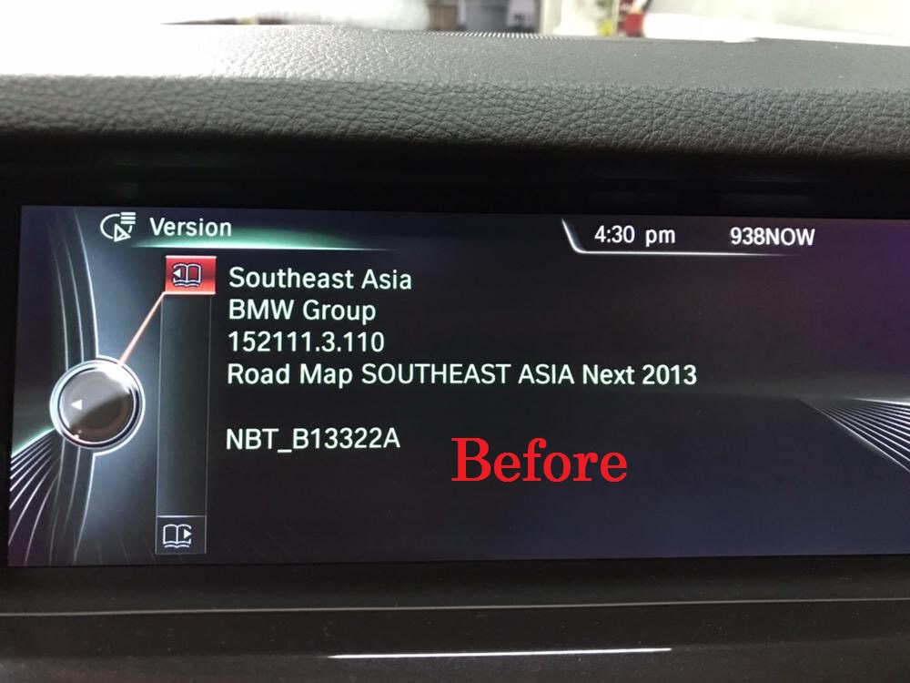
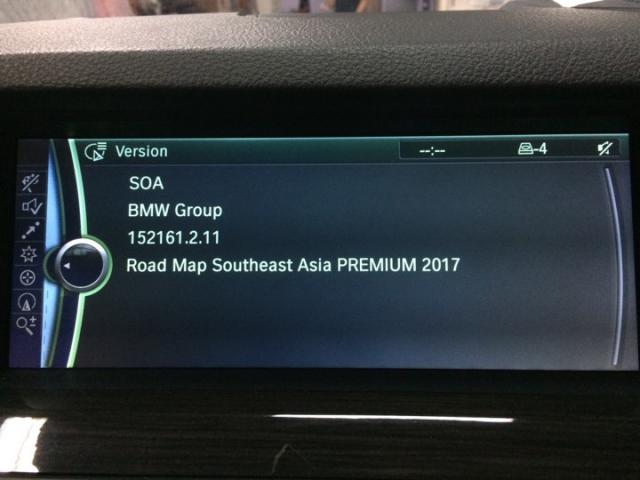
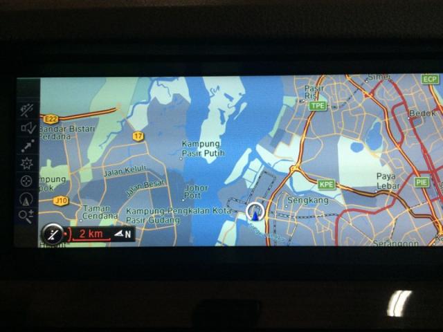
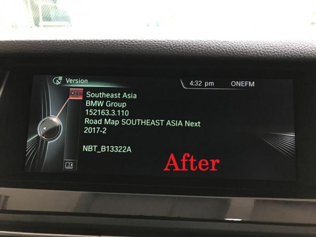
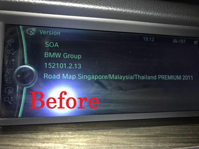
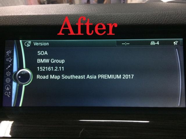
BMW navigation software update. now NBT & CIC system update is available. Before and After!!! MCE is added in new version.

-
I just got a samsung sgs2. Anyone here can fast forward me to any Apps that does a good GPS guided job on the roads?
-
Hi Am going on self-drive holiday around UK. Is there any good Andriod App that will work without wifi, just on GPS signal ? Or How can i buy/get a UK Map for my current GarminGPS ? Many thanks.
-
Hi all, Anyone using the latest 2014 kenwood model? May i know where to buy this MHL cable. KCA-MH100?
-
going to japan in early april for cherry blossom. arrive in nagoya and return from osaka drive from nagoya > takayama > shirakawago > kanazawa > nagoya > kyoto (via shinkansen) > osaka (via train) using samsung s4 android phone. i could not find any good navigation software for android. is it ok to rely on google maps? when arrive in airport, is it better to rent the internet device/dongle or sim card with internet (unlimited usage) for 7 days? planning to get a central nippon expressway pass for 2014 http://global.c-nexco.co.jp/en/cep/expressway_pass2014overview.html only available in toyota and times (mazda) ... so must rent toyota or mazda car liao ... any advice is appreciated. thanks!
-

Motorcyclists can finally have a navigation system too!
RchLuvSlly posted a blog entry in MyAutoBlog
A comprehensive navigation system has become a standard for most, if not all, of today's cars. However, the same can't be said of motorcycles, at least not yet. With that being said, a motorcyclist will have to go through all the difficulties in reading a paper map if he wants to get the right direction to where he's heading. But now, things are about to change, thanks to a Russian company. This company is planning to come up with a solution known as the LiveMap. Featuring an earphone, a microphone, a light sensor, and - the best part - a micro display, this navigation system will project directions in the form of a heads-up display, just like what we can find featured in today's fighter jets. How cool does that sound? Unlike Google Glass - which projects images on the upper right hand side, the LiveMap will project directions right on the centre of the visor of the helmet the motorcyclist is wearing. And, thanks to the light sensor, the directions on the visor will remain transparent regardless of whether it is in the day or night. I would say that this is absolutely important as it ensures safety. A digital compass and an integrated gyroscope are also in place to make sure that the motorcyclist gets the correct orientation of the projection displayed on his visor, even if he's leaning the bike or tilting his head. Wow, this is yet another cool feature to anticipate, isn't it? But then, there's another problem, what about the power supply the helmet is going to need? Well, counting on a couple of lithium-ion batteries, the Russian company behind the solution claims that the helmet is likely to last a day. However, a USB charge plug will also come in handy should the motorcyclist require extra juice. How does this augmented-reality helmet sound? Well, if you're interested, you may want to help make it become a reality as the company is currently trying to raise US$150,000 (S$191,235) via Indiegogo. That amount is required to build a prototype that should work as expected. Then, if everything goes well, one of this LiveMap helmets may demand around US$2,000 (S$2,550) from any motorcyclist interested in it. Of course, there're always chances that prices may go down, even if we may have to wait for another decade. -
Was thinking of installing a In Car Entertainment DVD player with GPS and would like one with Garmin Navigation. Not too sure if any of the sifu here can let me know which model of DVD Player comes with Garmin. Thanks
-
SINGAPORE: A Singapore Armed Forces (SAF) full-time National Serviceman (NSF) died on Tuesday during a navigation exercise. Specialist Cadet (SCT) Ee Chun Sheng, 21, was found unconscious at about 5.11pm while participating in the exercise at Ama Keng Training Area at Lim Chu Kang. An SAF medic went on site and tried to resuscitate SCT Ee at about 5.15pm. The serviceman was evacuated via a safety vehicle to the Tengah Air Base Medical Centre and arrived at about 5.39pm where an SAF doctor attended to him. SCT Ee was then sent by ambulance to the National University Hospital (NUH) at 6.05pm and arrived at 6.32pm. SAF doctor and medic continued to resuscitate him enroute to the hospital. SCT Ee was pronounced dead at 9.03pm at NUH. The Ministry of Defence (MINDEF) and the SAF extend their deepest condolences to the family of the late SCT Ee. The SAF is assisting the family in their time of grief and is investigating the incident. - CNA/fa
-
Thinking of buying one. Any recommendation?
-
hi guys, i have a stand alone gps but sometimes the gps suddenly hang when im on the road and its really kinda headache when this happen so is there any navigation application on iphone which provide really good navigation and won`t be cut off if i got any phone calls coming in and sms.. if there is such a application please do intro to me.. thank you so much! (but i don`t want too expensive want)
-
Please recommend and share your experience with GPS car Navigation system i really louya pok at driving directions and will confirm go wrong route. definitely buying a GPS. now here's what i am looking for.... - budget is $350 to $410 - can key in postal code/building name/road name to get to destination - voice guidance to tell me directions, eg, to keep left "keep left, turn left in 300m", "keep left, turn left in 200m" - updated and updatable map - place where i can buy it also pls share any other experience you have with GPS and the model you are using
-
Have you ever wondered whether your iPhone can replace your full-sized car GPS set? Well, the default Maps app that comes with your phone would hardly come close. With limited search parameters, the need for 3G connectivity and the lack of a voiced turn-by-turn navigation function, it is at best a map with GPS functionality. Good enough to figure out where you are, but not quite capable of directing you from one place to another like a proper GPS. If you want some thing that comes a little bit closer, you have to (not surprisingly) pay. Yet, a search on the iTunes app store will reveal many GPS apps, all of which cost money and with no way of testing it before payment; how do we know which is bang for your buck? No fears, because GPS crazy me actually bought 3 of the most popular ones and will let you know which one is the best in this short and sweet iPhone GPS shootout. Let's bring on the contenders! Mobile Maps SEA Cost: Extremely pricey! This app costs a whopping USD $59.99. Whether it is worth it though is your call; after all a full function GPS set is likely to cost much more! Likes: Easy to use and intuitive interface. Navigating the various functions are simple and the 6 digit postal code search is speedy. I especially like the ability to set your Home address which gives you a one touch method of getting yourself home in less time than it takes for the lights to change. Among the 3 apps, it also has the most functions, including internet support. In addition, it has the most comprehensive list of maps as it covers more countries within SEA; including Singapore, Malaysia, Brunei, Indonesia, Thailand and Manila City (Philippines). This may be a boon for those road-trip warriors amongst us. Dislikes: The price and the fact that the maps are updated only by the manufacturer. This may be problematic if the manufacturer were to delay the release map updates. Papago! Singapore + Malaysia Cost: This is the cheapest of the lot. Starting at USD $19.99 for the Lite version to $29.99 for the Pro version, this app is by far the cheapest of the lot. The Lite version simply does not have a 3D navigation feature. Compared with the others, it is practically a steal. Likes: This app uses malfreemaps, which is something that users of Garmin sets would already be very familiar with. As the maps are community maintained, you get the best and most updated Points of Interest (POI) information which are maintained by users themselves. The level of detail is unrivaled. The maps are also updated most frequently; typically every one to two weeks. HOWEVER, do note that only tech savvy folks who know how to change the map used by this app will be able to access the latest maps released by the malfreemaps community. For most of us, we have to wait for the app creator to release an update to the app along with the latest map, which is not as frequent as the map releases. Dislikes: Navigation around the functions are a little less intuitive for my liking. It is not the best one to use if you wanted to run it on the spur of the moment; say if you made a wrong turn while driving and got lost. You will probably have to find a quiet place to pull over and operate it. In addition, some users report problems with inability to seek out satellite signals. However, this should be resolvable by simply deleting the app and reinstalling it or by removing any reflective covers that you might have cocooned your precious phone in. TomTom Malaysia & Singapore Cost: Another pricey one! Price is also USD $59.99. Likes: A pretty decent and clean interface. This app also comes from an established GPS navigation company and hence the map is likely to be accurate and reliable. Coverage of Singapore, Malaysia and Brunei. Recently released updated map. Dislikes: Search function is not intuitive and may be difficult to use. Earlier versions took a long time to locate the satellite signal and may be unstable on older iPhones. However, it may have been resolved with the latest update but I have yet to test run it sufficiently. For its price, I expected more. Final Verdict Papago! Singapore + Malaysia. The availability and possibility of swopping in updated maps makes this a winner. After all, what is the use of an outdated map? More importantly, at its low price point, the interface and lack of full functionality is something that can be overlooked.
-
 Hi Guys, I bought the HTC Touch Cruise 2009 sometime in June this year. Started to use the Navigation System (Papago) function lately and realised that the map for Singapore is not updated. It does not have KPE in it. I've tried contacting HTC support but was told to approach Papago for product support. Tried contacting Papago at http://www.papago.com.sg/ but no one answers the call I've made. Any frequent users of Papago can share with me on where and how to update the maps for my hp? I am in need of updated maps for Malaysia and Singapore....help~
 -
Hi All Saw BM offering Built-in Garmin Navigation function in Altis on Saturday ST, and then same day went to Suntec IT Show and saw Garmin booth very crowded, many pple buying the portable navigation device. Thus, sudden thought, would like to check if given a choice, do you prefer your car to have a built-in navi function or prefer to get a portable one (assuming both using Garmin software) Btw, I do a check, BM offering Garmin is using Teleatlas map while if buying at the IT show or other places like Carrefour, we can go to website such as Malsingmap.com to download without charges. Anyone know which map is better, Teleatlas or Malsingmap? Cheers
-
I'm new to this GPS toys & just got my hands on the new N95. I find the nokia maps & navigation too complex to use, requiring online connection & $$$... Any other alternative?
-
Hi all, Was contemplating whether its a practical solution as a GPS as well as phone as well? Any owner here having complaints or compliments? Appreciate any form of feedback. Thks
-
I'm thinking of getting an in-car navigation system/GPS as I have been getting lost too often. Figured that it might save me more in the long run by cutting down the needless petrol spent in going in a merry-go-round. (Sometimes I feel like I'm like a shark. Have to circle the location a few times before I zero in on the actual spot. ) Anyway, thinking if any of the bros here can share more info. like: - Where can I shop for a in-car navigation system system? Any recommendations? - What are the more popular and reliable models, and how much do they cost roughly? I was told that Diracc has installed the navigation system in their latest Civic range and the navigation panel stows away into the dashboard when the car engine switches off. Sounds cool. Anyone knows how to get a similar system installed? Thanks in advance for any advice!
-
Hi all kakis, Need some help here, my uncle is a holland king so he is thinking of getting a GPS kit. 1) How much does it cost? (include installation) 2) Must have voice activation (e.g. turn left ahead) Thanks aot
-
As above.. Im a new driver and a noob in finding directions, so would like one in my car.. Any brand and model to recommend? Price? Thanks.. Cheers..
-
Just want to find out whether these funtions worth the $2500 to pay to install for nissan car owners. Any comment?